As the early effects of a “Super” El Niño are seen and felt across the West, I am noticing how the storms are already testing dam infrastructure. Knowing there are reservoirs along nearly every waterway across California, including in the East Bay hills above my neighborhood, I set out to understand how our downstream communities can monitor reservoir conditions and prepare for deluge events. I ended up with more questions than answers. And, at the same time, with even more certainty that possibility of dam failure is something everyone living downstream of one, especially an earthen dam, should be aware of and stay prepared for, together.
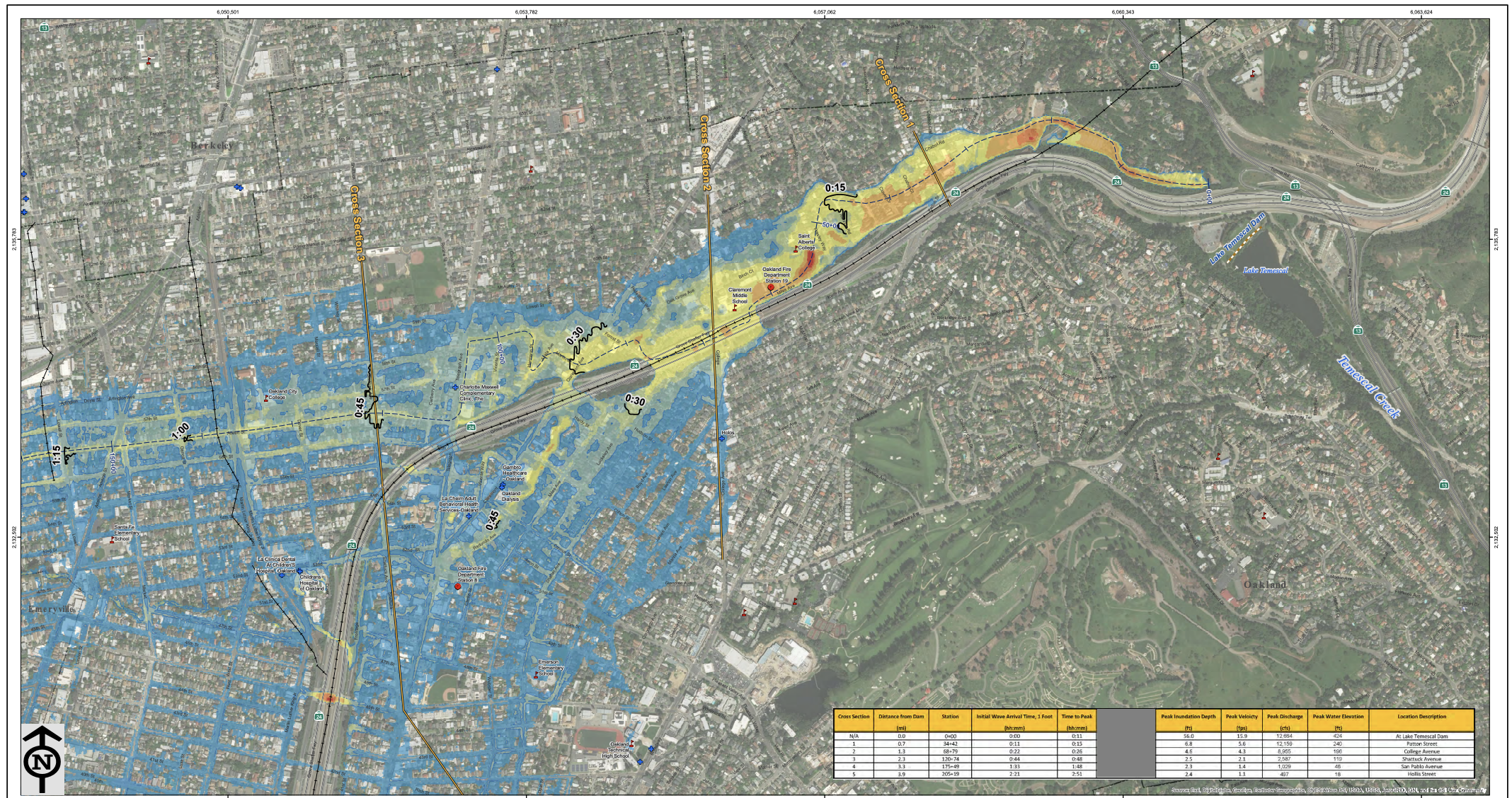
The reservoir known today as Lake Temescal was created in 1868 when Anthony Chabot’s company built an earthen dam across Temescal Creek. This inundation map from the California Department of Water Resources shows the path and estimated depth of the water in the case of a “Sunny Day Hypothetical Failure.”
Part 1 ~ 8° of Warming
The World Meteorological Association defines El Niño and La Niña as “opposite phases of a naturally occurring climate pattern known as the El Niño-Southern Oscillation (ENSO).” Every two to seven years, these phases fluctuate ocean temperatures in the central and eastern equatorial Pacific, as well as in the overlying atmosphere.
The name originates with Peruvian fishermen and sailors who noticed a warm current, associated with reduced fish catches, and named it El Niño (“the Christ Child”), likely because it typically became noticeable around Christmas. In 2026, scientists have been sounding the alarm around the El Niño patterns, as unusually warm ocean surface temperatures in the central and eastern Pacific began indicating the possibility of a “Super” Niño.
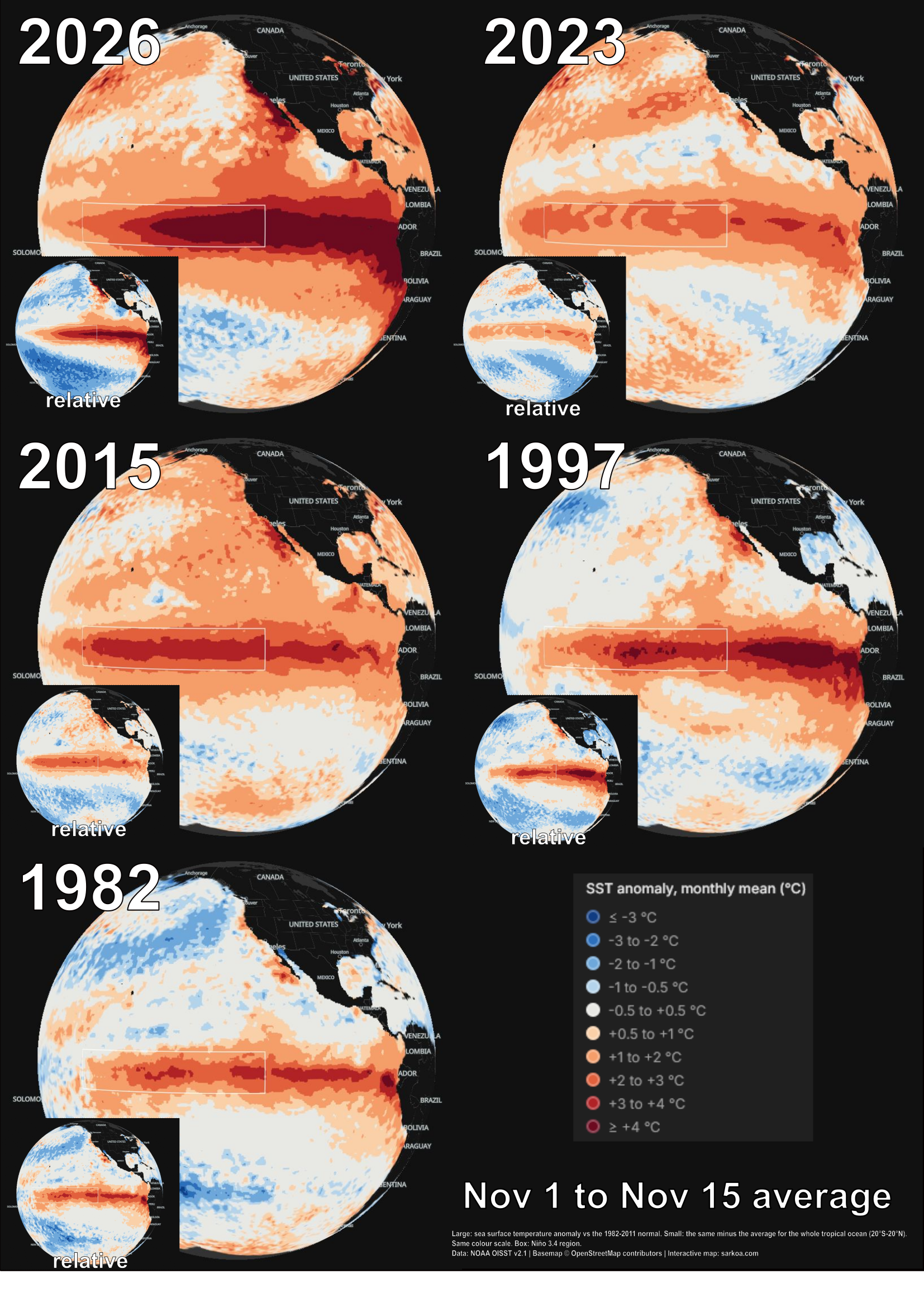
This visual from Reddit shows the relative and absolute differences in temperature measurements between the 2026 El Niño compared to previous years between November 1st to 15th. The highest measurement shows 4° warming, 4° cooler than what’s been recorded in 2026.
If you haven’t yet heard about the “Super” El Niño or want to learn more, I highly recommend listening to the Ologies podcast episode: Extreme Meteorology (EL NIÑO) with Dr. Marshall Shepherd. Here’s what stuck out most to me from the conversation:
Scientists start considering an El Niño when water temperatures in the central Pacific reach 0.5° Celsius above average. At the time of the interview, temperatures were already 2 to 3 degrees warmer, and expected to get hotter.
Additionally concerning to Dr. Shepard was subsurface water temperatures, citing estimates that they are already 8°C warmer than average.
The takeaway: Dr. Shepard outlines that during previous El Niño years California has seen immensely strong storm events, rainstorms, and mudslides. At the time of the interview, ocean temperatures were already measuring significantly above what was previously considered “peak” heat. Meanwhile, the peak storms don’t arrive in Northern California until February (historically). Meaning, the ocean is expected to get hotter and the weather more extreme.
From Drought to Deluge
When I moved to Oakland in 2016, the drought was declared “over” as we experienced deluge rains. We lived in Adams Point at the time, and I remember trying to commute across flooded streets amid days of nonstop rain. Albert Hammond’s lyric, “it doesn’t rain in California, it pours” rang true.
Later that winter season, in February of 2017, the spillway failure at the Lake Oroville reservoir showed us all just how quickly things can change and how a season of heavy rains can put pressure on California’s earthen dams.
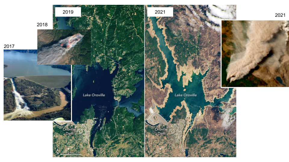
Timeline of major weather events surrounding the Lake Oroville reservoir, damming the waters of the Feather River, shown between 2017 - 2021 left to right: Spillway crisis, the Camp Fire, deluge fill, drought fill, Dixie Fire.
In the New York Times reporting on the 2017 spillway crisis titled, The Trillion Gallon Question, Dale Cox, a former project manager at the United States Geological Survey told the reporter,
“California’s dams are unprepared for extreme weather because state water authorities have a false sense of how bad flooding can get.”
Some of this miscalculation arises from the failure to account for climate change, a risk that will only intensify as the atmosphere continues to warm and the carrying capacity of California’s atmospheric rivers increases.
Dr. Daniel Swain, a climate scientist focused on the dynamics and impacts of extreme events, is quoted by the New York Times report saying:
“All of this infrastructure is designed for a climate that no longer exists.”
The takeaway: Since California was only colonized by the United States 250 years ago, the data used to predict weather patterns only includes a very short window of time.
What we know about weather in California, and what we think the dams can actually withstand, is based on data from the past 100 years, which were an “unusually placid period” in the region’s weather.
What could this mean for the East Bay and specifically, the Temescal Creek watershed?
In 1868, Anthony Chabot’s company built an earthen dam across the waterway known today as Temescal Creek, creating a reservoir with a storage capacity of 200 acre feet of water (approximately 65 million gallons).
Originally built to support settlement of the newly established and rapidly growing City of Oakland, the reservoir served approximately 10,000 residents at the time.
In 1929, 100 miles east of Oakland, the Pardee Dam was built across the Mokelumne River. With over 1,000 times the capacity of the Temescal reservoir, the local reservoir in the East Bay hills became functionally obsolete.
No longer needed for drinking water, it took on a new purpose; in 1936, the Temescal Regional Recreation Area became one of the East Bay District's first three parks.
Today, the reservoir of water is held by an earthen dam classified by the U.S. Army Corps of Engineers (USACE) as an Extremely High hazard, defined as: Expected to cause considerable loss of human life or would result in an inundation area with a population of 1,000 or more.
Yet, even with a storage capacity of 200 acre feet, the Lake Temescal reservoir is significantly smaller than the Chabot reservoir further south in the East Bay. Chabot’s dammed section of San Leandro Creek has a capacity of 10,350 acre feet, 50 times larger than the Lake Temescal reservoir. Both are earthen dams, so a sequential failure scenario in which both dams failed, would be a disaster.
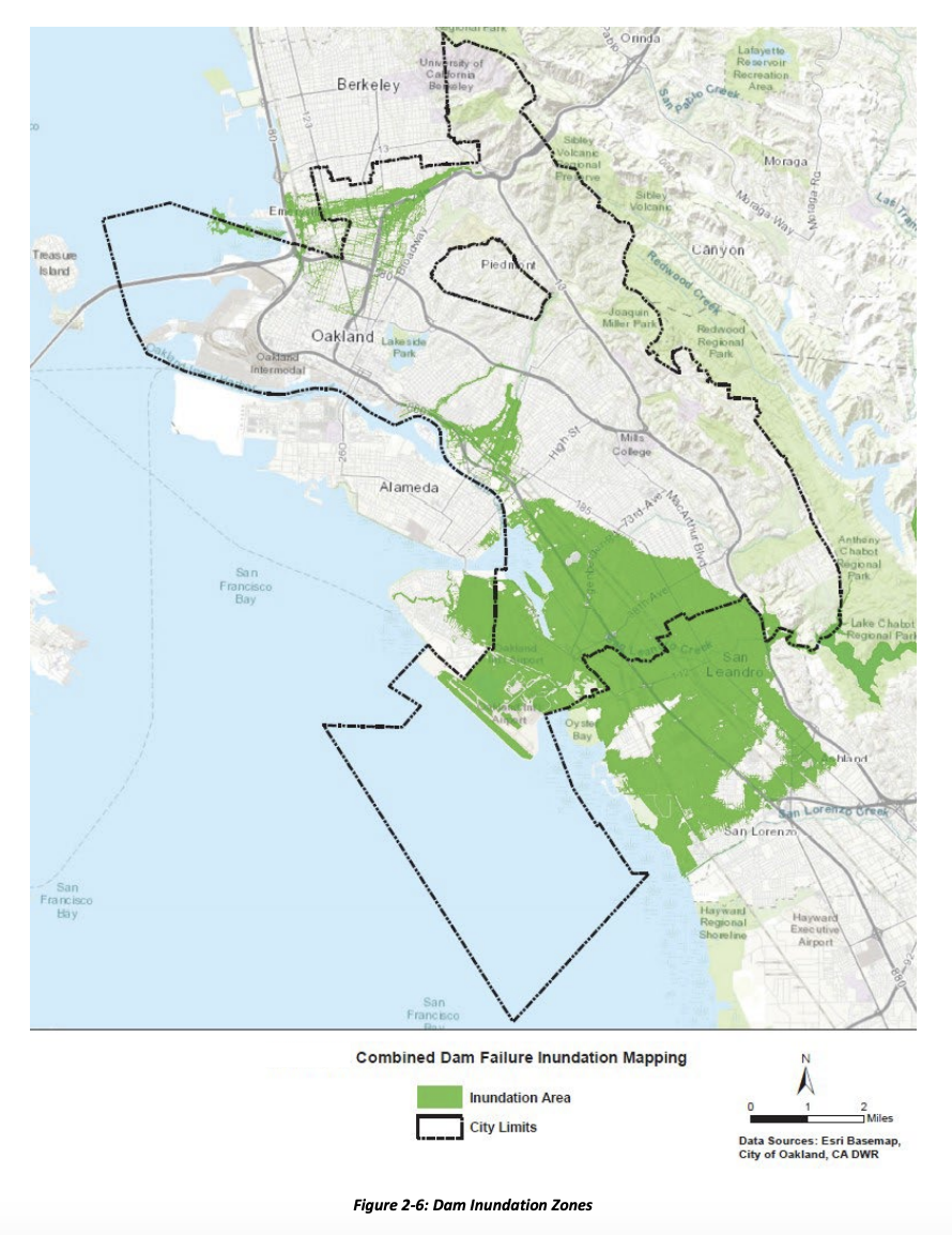
The City of Oakland Emergency Operations Plan lists the Lake Temescal dam of particular concern since it straddles the main trace of the Hayward fault. The image above maps inundation in the case of “combined dam failure” of both Lake Temescal and Lake Chabot.